Countrywide mapping and assessment of organic carbon saturation in the topsoil using machine learning-based pedotransfer function with uncertainty propagationsggf

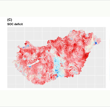
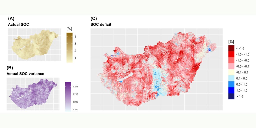
Stakeholders and policymakers have been becoming more and more interested not just in the potential organic carbon (SOC) saturation level of soils but also in spatially explicit information on the degree of SOC deficit, which can support future policy and sustainable management strategies, and carbon sequestration-associated spatial planning. Thus the objective of our study was to develop a cubist-based pedotransfer function (PTF) for predicting and mapping the saturated SOC content of the topsoils (0–30 cm) in Hungary and then compare the resulting map with the actual SOC map to determine and assess the degree of SOC deficit. It was assumed that topsoils covered by permanent forests can be practically considered as saturated in SOC. Using the monitoring points of the Hungarian Soil Information and Monitoring System located in forests as reference soil profiles, we developed a cubist-based PTF. The transparent model structure provided by cubist allowed to show that not just the physicochemical properties of soils (e.g., texture, and pH) but also environmental conditions, such as topography (e.g., slope, altitude, and topographical position) and climate (e.g., long-term mean annual temperature, and evaporation), characterizing landscape are important factors in predicting the level of SOC saturation. Our results also pointed out that there is SOC deficit on large part of the country (∼80%) showing high spatial variability. It was also revealed that the most considerable potential for additional SOC sequestration can be found related to soils with medium to high actual SOC content.

The research has been published with open access in CATENA (D1, IF: 6.367):


Szatmári, G.; Pásztor, L.; Laborczi, A.; Illés, G.; Bakacsi, Zs.; Zacháry, D.; Filep, T.; Szalai, Z.; Jakab, G. Countrywide mapping and assessment of organic carbon saturation in the topsoil using machine learning-based pedotransfer function with uncertainty propagation. CATENA 2023, 227, 107086.
https://doi.org/10.1016/j.catena.2023.107086

National cropland evaluation: based on remote sensing data and field measurements

The importance of variables such as different soil parameters (soil type, pH, texture, organic matter, nitrogen, phosphorus and potassium content), average monthly precipitation, average monthly temperature and geographical coordinates were also considered in the model. The models were calculated for the three most important crops (wheat, maize, sunflower). In a final step, the resulting values were weighted by topography. The resulting maps contain values between 0 and 100 with a resolution of 100 metres. The proposed methodology can be used for integrated monitoring of biomass productivity in cadastral systems, land use planning and agricultural development programmes, among other possible applications. The research has been published in the open access journal Remote Sensing (Q1, IF: 5.349):

Csikós, N.; Szabó, B.; Hermann, T.; Laborczi, A.; Matus, J.; Pásztor, L.; Szatmári, G.; Takács, K.; Tóth, G. Cropland Productivity Evaluation: A 100 m Resolution Country Assessment Combining Earth Observation and Direct Measurements. Remote Sens. 2023, 15, 1236.

Results of “National Ecosystem Services Mapping and Assessment” in publications co-authored by resarchers of TAKI

The results of the project are gradually being published in various international journals.

Basic concept of ecosystem assessment:
Vári Á, Tanács E, Tormáné Kovács E, Kalóczkai Á, Arany I, Czúcz B, Bereczki K, Belényesi M, Csákvári E, Kiss M, Fabók V, Fodor LK, Koncz P, Lehoczki R, Pásztor L, Pataki R, Rezneki R, Szerényi Z, Török K, Zölei A, Zsembery Z, Kovács-Hostyánszki A. 2022.
National Ecosystem Services Assessment in Hungary: Framework, Process and Conceptual Questions. Sustainability 14(19):12847, DOI: 10.3390/su141912847

Compilation of the new Ecosystem Map of Hungary:
Tanács E, Belényesi M, Lehoczki R, Pataki R, Petrik O, Standovár T, Pásztor L, Laborczi A, Szatmári G, Molnár Zs, Bede-Fazekas Á, Somodi I, Kristóf D, Kovács-Hostyánszki A, Török K, Kisné Fodor L, Zsembery Z, Friedl Z, Maucha G. 2021.
Compiling a high-resolution country-level ecosystem map to support environmental policy: methodological challenges and solutions from Hungary. Geocarto International, DOI: 10.1080/10106049.2021.2005158

Flood regulation:
Vári Á, Kozma Zs, Pataki B, Jolánkai Zs, Kardos M, Decsi B, Pinke Zs, Jolánkai G, Pásztor L, Condé S, Sonderegger G, Czúcz B.
Disentangling the ecosystem service ‘flood regulation’: Mechanisms and relevant ecosystem condition characteristics. Ambio, DOI: 10.1007/s13280-022-01708-0

Assessment of ecosystems condition in Hungary:
Tanács E, Bede-Fazekas Á, Csecserits A, Kisné Fodor L, Pásztor L, Somodi I, Standovár T, Zlinszky A, Zsembery Z, Vári Á. 2022.
Assessing ecosystem condition at the national level in Hungary – indicators, approaches, challenges. One Ecosystem 7: e81543, DOI: 10.3897/oneeco.7.e81543

High-Resolution mapping and assessment of salt-affectedness on arable lands using advanced statistical approaches

The research was funded by the National Research, Development and Innovation Office (NKFIH), grant number K-124290. Their results illustrated that ensemble machine learning combined with multivariate geostatistics could be a promising method not just for jointly modelling and mapping the spatial distribution of different indicators of salt-affected soils (e.g., pH, electrical conductivity and sodium adsorption ratio) at high spatial resolution but also in assessing salt-affectedness on arable lands at the field scale. Furthermore, their maps can help the land users to select the appropriate agrotechnical operation for improving soil quality and yield. Their results and findings have been published open access in Agronomy (Q1, IF: 3.949):

Hateffard F, Balog K*, Tóth T, Mészáros J, Árvai M, Kovács Zs A, Szűcs-Vásárhelyi N, Koós S, László P, Novák T J, Pásztor L, Szatmári G, 2022: High-Resolution Mapping and Assessment of Salt-Affectedness on Arable Lands by the Combination of Ensemble Learning and Multivariate Geostatistics. AGRONOMY 12(8), 1858.